


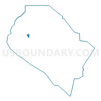
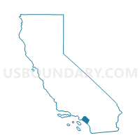
Voting District 14226, Orange County, California
About
Outline

Summary
| Unique Area Identifier | 535765 |
| Name | Voting District 14226 |
| County | Orange County |
| State | California |
| Area (square miles) | 0.79 |
| Land Area (square miles) | 0.79 |
| Water Area (square miles) | 0.00 |
| % of Land Area | 100.00 |
| % of Water Area | 0.00 |
| Latitude of the Internal Point | 33.74346260 |
| Longtitude of the Internal Point | -117.95155230 |
Maps

Graphs
Select a template below for downloading or customizing gragh for Voting District 14226, Orange County, California


Neighbors
Neighoring Voting District (by Name) Neighboring Voting District on the Map
- Voting District 11536, Orange County, CA
- Voting District 11746, Orange County, CA
- Voting District 11747, Orange County, CA
- Voting District 11751, Orange County, CA
- Voting District 11756, Orange County, CA
- Voting District 11926, Orange County, CA
- Voting District 11941, Orange County, CA
- Voting District 14206, Orange County, CA
- Voting District 14221, Orange County, CA
- Voting District 14241, Orange County, CA
- Voting District 14246, Orange County, CA
- Voting District 14261, Orange County, CA
- Voting District 14356, Orange County, CA
- Voting District 21736, Orange County, CA
- Voting District 21741, Orange County, CA
Top 10 Neighboring County Subdivision (by Population) Neighboring County Subdivision on the Map
- Anaheim-Santa Ana-Garden Grove CCD, Orange County, CA (1,648,519)
- North Coast CCD, Orange County, CA (366,151)
Top 10 Neighboring Place (by Population) Neighboring Place on the Map
Top 10 Neighboring Unified School District (by Population) Neighboring Unified School District on the Map
Top 10 Neighboring State Legislative District Lower Chamber (by Population) Neighboring State Legislative District Lower Chamber on the Map
Top 10 Neighboring State Legislative District Upper Chamber (by Population) Neighboring State Legislative District Upper Chamber on the Map
Top 10 Neighboring 111th Congressional District (by Population) Neighboring 111th Congressional District on the Map
Top 10 Neighboring Census Tract (by Population) Neighboring Census Tract on the Map
- Census Tract 889.03, Orange County, CA (8,585)
- Census Tract 992.03, Orange County, CA (6,029)
- Census Tract 889.04, Orange County, CA (5,766)
- Census Tract 992.23, Orange County, CA (5,102)
- Census Tract 992.04, Orange County, CA (4,729)